A 20-yr database (1997-2017) of co-seismic displacements from GPS recordings in the Aegean area and their scaling with Mw and hypocentral distance


Published: Nov 20, 2018
Keywords:
GNSS Aegean displacement earthquake scaling
Athanassios Ganas
https://orcid.org/0000-0002-1937-3283
Nikoletta Andritsou
https://orcid.org/0000-0002-9371-5093
Chrysanthi Kosma
Panagiotis Argyrakis
Varvara Tsironi
https://orcid.org/0000-0002-5701-3262
George Drakatos
Abstract

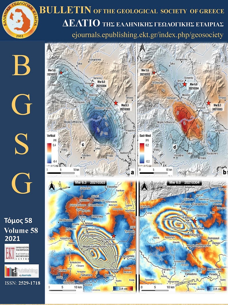
We describe and make available a dataset of 64 data points of Global Positioning System (GPS) displacements for significant, shallow earthquakes in Greece during the period 1997-2017. The displacement data can be used by earthquake geologists, engineers and seismologists in an effort to better understand the faulting process, the rupture mechanics, the pattern of ground-motions, and in engineering applications. We include recordings from GNSS networks at near-source to regional distances (2–132 km) for 11 earthquakes between global CMT moment magnitudes (Mw) 5.5 and 6.9. We also model the magnitude scaling properties of peak ground horizontal displacements (PGD and PGD-S) for these events using L1-norm minimisation regression. Our data indicate an almost linear attenuation of seismic strain with distance for this range of seismic magnitudes. We developed a set of relationships based on PGD (in cm) and distance to hypocentre R (in km), which may be used for the rapid estimation of the earthquake magnitude in near real-time.

MwPGD = [LOG(PGD) + 8.2849]/(1.6810 – 0.2453LOGR)

MwPGD-S = [LOG(PGD-S) + 8.0839]/(1.6793 – 0.2447LOGR)

Article Details
  • Section
  • GNSS-Geodesy
Downloads
Download data is not yet available.
Author Biography
Athanassios Ganas, Editor-in-Chief 2016-2018; Research Director Institute of Geodynamics National Observatory of Athens
Editor-in-Chief BGSG 2016-2018
References
Atzori S., M. Manunta, G. Fornaro, A. Ganas, S. Salvi, 2008. Postseismic displacement of the 1999 Athens earthquake retrieved by the Differential Interferometry by Synthetic Aperture Radar time series, Journal of Geophysical Research, 113, B09309, doi:10.1029/2007JB005504.
Avallone A., P. Briole, A.M. Agatza-Balodimou, H. Billiris, O. Charade, C. Mitsakaki, A. Nercessian, K. Papazissi, D. Paradissis, G, Veis, 2004. Analysis of eleven years of deformation measured by GPS in the Corinth Rift Laboratory area, C.R. Geoscience, 336, 301-312.
Avallone A., et al., 2017. Near-source high-rate GPS, strong motion and InSAR observations to image the 2015 Lefkada (Greece) Earthquake rupture history, Scientific Reports 7, Article number: 10358, doi:10.1038/s41598-017-10431-w
Argyrakis, P. Ganas, A and Sagias, N., 2016. The NOANET GSAC (Geodesy Seamless Archive Centers) tool for GNSS data dissemination in SE Europe, ESC2016-144.
Bock, Y. and Melgar, D., 2016. Physical applications of GPS geodesy: a review. Reports on Progress in Physics, 79(10), p.106801.
Briole, P., P. Elias, I. Parcharidis, C. Bignami, G. Benekos, S. Samsonov, C. Kyriakopoulos, S. Stramondo, N. Chamot-Rooke, M.L. Drakatou, G. Drakatos, 2015. The seismic sequence of January–February 2014 at Cephalonia Island (Greece): constraints from SAR interferometry and GPS, Geophysical Journal International, 203, 3, 1528–1540, https://doi.org/10.1093/gji/ggv353
Cheloni D., et al. 2014. Coseismic and post‐seismic slip of the 2009 L'Aquila (central Italy) Mw 6.3 earthquake and implications for seismic potential along the Campotosto fault from joint inversion of high‐precision levelling, InSAR and GPS data, Tectonophysics, 622, 168–185, doi:10.1016/j.tecto.2014.03.009.
Chousianitis K., Ganas A., Papanikolaou M., Argyrakis P., Drakatos G. and Makropoulos K., 2013. Time series analysis of the NOANET CGPS stations, Bulletin of the Geological Society of Greece, vol. 47 (2), 508-517, http://dx.doi.org/10.12681/bgsg.11078
Chousianitis, K., A. Ganas, and C. P. Evangelidis, 2015. Strain and rotation rate patterns of mainland Greece from continuous GPS data and comparison between seismic and geodetic moment release, J. Geophys. Res. Solid Earth, 120, 3909–3931.
Chousianitis, K., A. O. Konca, G.-A. Tselentis, G. A. Papadopoulos, and M. Gianniou, 2016. Slip model of the 17 November 2015 Mw = 6.5 Lefkada earthquake from the joint inversion of geodetic and seismic data, Geophys. Res. Lett., 43, doi:10.1002/2016GL069764.
Chousianitis, K., and Konca, A.O., 2018. Coseismic slip distribution of the 12 June 2017 Mw = 6.3 Lesvos earthquake and imparted static stress changes to the neighboring crust. Journal of Geophysical Research Solid Earth, 123. https://doi.org/10.1029/2018JB015950
Crowell, B. W., D. Melgar, Y. Bock, J. S. Haase, and J. Geng, 2013. Earthquake magnitude scaling using seismogeodetic data, Geophys. Res. Lett., 40, 6089–6094, doi:10.1002/2013GL058391.
Crowell, B. W., D. A. Schmidt, P. Bodin, J. E. Vidale, J. Gomberg, J. Renate Hartog, V. C. Kress, T. I. Melbourne, M. Santillan, S. E. Minson, and D. G. Jamison, 2016. Demonstration of the Cascadia G‐FAST geodetic earthquake early warning system for the Nisqually, Washington, earthquake, Seismological Research Letters 87(4), pp.930-943.
Devoti, R. L. Anderlini, M. Anzidei, A. Esposito, A. Galvani, G. Pietrantonio, A. Pisani, F. Riguzzi, V. Sepe, E. Serpelloni, 2012. The coseismic and postseismic deformation of the L’Aquila, 2009 earthquake from repeated GPS measurements. Italian Journal of Geosciences; 131 (3): 348–358. doi: https://doi.org/10.3301/IJG.2012.15
Estey, L. H. and Meertens, C. M., 1999. TEQC: The Multi-Purpose Toolkit for GPS/GLONASS Data, GPS Solutions, 3, 1, 42-49, doi:10.1007/PL00012778.
Ganas, A., G. Drakatos, S. Rontogianni, C. Tsimi, P. Petrou, M. Papanikolaou, P. Argyrakis, K. Boukouras, N. Melis and G. Stavrakakis, 2008. NOANET: the new permanent GPS network for Geodynamics in Greece. Geophysical Research Abstracts, Vol. 10, EGU2008-A-04380.
Ganas, A., Serpelloni, E., Drakatos, G., Kolligri, M., Adamis, I., Tsimi, Ch. and Batsi, E., 2009. The Mw 6.4 SW Achaia (Western Greece) Earthquake of 8 June 2008: Seismological, Field, GPS Observations, and Stress Modeling, Journal of Earthquake Engineering, 13:8, 1101 — 1124.
Ganas, A., K. Chousianitis, G. Drakatos, M. Papanikolaou, P. Argyrakis, M. Kolligri, P. Petrou, E. Batsi, and C. Tsimi, 2011. NOANET: High-rate GPS Network for Seismology and Geodynamics in Greece. Geophysical Research Abstracts, Vol. 13, EGU2011-4840, EGU General Assembly 2011
Ganas, A., K. Chousianitis, M. Papanikolaou, P. Argyrakis, G. Drakatos, K. Makropoulos, 2012. Continuous GPS Velocity Profiles and Baseline Rate Changes in Central and Western Greece: Comparison with Geological Data, In: Book of Abstracts, 33rd General Assembly of ESC, 19-24 August 2012 Moscow, p. 125.
Ganas, A., Marinou A, Anastasiou D., Paradissis D., Papazissi K., Tzavaras P., Drakatos G., 2013a. GPS-derived estimates of crustal deformation in the central and north Ionian Sea, Greece: 3-yr results from NOANET continuous network data. Journal of Geodynamics, 67, 62– 71. http://dx.doi.org/10.1016/j.jog.2012.05.010
Ganas, A., Chousianitis, K., Batsi, E., Kolligri, M., Agalos, A., Chouliaras, G., & Makropoulos, K., 2013b. The January 2010 Efpalion earthquakes (Gulf of Corinth, Central Greece): earthquake interactions and blind normal faulting. Journal of Seismology, 17 (2), 465-484, http://dx.doi.org/10.1007/s10950-012-9331-6
Ganas A., Cannavo F., Chousianitis K., Kassaras I., and Drakatos G., 2015. Displacements recorded on continuous GPS stations following the 2014 M6 Cephalonia (Greece) earthquakes: dynamic characteristics and kinematic implications. Acta Geodyn. Geomater., Vol. 12, No. 1 (177), 5–27, 10.13168/AGG.2015.0005.
Ganas, A., Elias, P., Bozionelos, G., Papathanassiou, G., Avallone, A., Papastergios, A., Valkaniotis, S., Parcharidis, I., Briole, P., 2016. Coseismic deformation, field observations and seismic fault of the 17 November 2015 M = 6.5, Lefkada Island, Greece earthquake, Tectonophysics, 687, 210-222, http://dx.doi.org/10.1016/j.tecto.2016.08.012
Ganas, A, Kourkouli, P, Briole, P, Moshou, A, Elias, P, Parcharidis, I, 2018. Coseismic Displacements from Moderate-Size Earthquakes Mapped by Sentinel-1 Differential Interferometry: The Case of February 2017 Gulpinar Earthquake Sequence (Biga Peninsula, Turkey). Remote Sens., 10, 1089, http://www.mdpi.com/2072-4292/10/7/1089
Ganas, A. et al., in review. The July 20, 2017 M6.6 Kos earthquake: seismic and geodetic evidence for an active north-dipping normal fault at the western end of the Gulf of Gökova (SE Aegean Sea).
Geng, T., X. Xie, R. Fang, X. Su, Q. Zhao, G. Liu, H. Li, C. Shi, and J. Liu, 2016. Real-time capture of seismic waves using high-rate multi-GNSS observations: Application to the 2015 Mw 7.8 Nepal earthquake, Geophys. Res. Lett., 43, 161–167, doi:10.1002/2015GL067044.
Geng J., Jiang P., Liu J. 2017. Integrating GPS with GLONASS for high-rate seismogeodesy. Geophys. Res. Lett. 44, 3139-3146. doi:10.1002/2017GL072808
Gianniou, M., 2011. Detecting permanent displacements caused by earthquake using data from the HEPOS network, in Proceedings of EUREF 2011 Symposium, May 25–28 2011, Chisinau, Moldova.
Hilla, S., 2004. Plotting pseudorange multipath with respect to satellite azimuth and elevation. GPS Solutions, 8: 44. https://doi.org/10.1007/s10291-004-0086-6.
Hollenstein, Ch., A. Geiger, H.-G. Kahle, G. Veis, 2006. CGPS time-series and trajectories of crustal motion along the West Hellenic Arc, Geophysical Journal International, 164, 1, 182–191, https://doi.org/10.1111/j.1365-246X.2005.02804.x
Hollenstein, Ch., M. D. Müller, A. Geiger, H.-G. Kahle, 2008. GPS-Derived Coseismic Displacements Associated with the 2001 Skyros and 2003 Lefkada Earthquakes in Greece. Bulletin of the Seismological Society of America; 98 (1): 149–161. doi: https://doi.org/10.1785/0120060259
Howell, A., K. Palamartchouk, X. Papanikolaou, D. Paradissis, C. Raptakis, A. Copley, P. England, J. Jackson, 2017. The 2008 Methoni earthquake sequence: the relationship between the earthquake cycle on the subduction interface and coastal uplift in SW Greece, Geophysical J. International, 208, 1592–1610, https://doi.org/10.1093/gji/ggw462
Hreinsdottir, S., T. Arnadottir, J. Decriem, H. Geirsson, A. Tryggvason, R. A. Bennett, and P. LaFemina, 2009. A complex earthquake sequence captured by the continuous GPS network in SW Iceland, Geophys. Res. Lett., 36, L12309, doi:10.1029/2009GL038391.
Huang M-H, D. Dreger, R. Bürgmann, S-H Yoo, M. Hashimoto, 2013. Joint inversion of seismic and geodetic data for the source of the 2010 March 4, Mw 6.3 Jia-Shian, SW Taiwan, earthquake, Geophysical Journal International, 193, 3, 1608–1626, https://doi.org/10.1093/gji/ggt058
Ilieva, M., P. Briole, A. Ganas, D. Dimitrov, P. Elias, A. Mouratidis, R. Charara, 2016. Fault plane modelling of the 2003 August 14 Lefkada Island (Greece) earthquake based on the analysis of ENVISAT SAR interferograms, Tectonophysics, 693, 47-65, http://dx.doi.org/10.1016/j.tecto.2016.10.021
Johanson, I., and R. Bürgmann, 2010. Coseismic and postseismic slip from the 2003 San Simeon earthquake and their effects on backthrust slip and the 2004 Parkfield earthquake, J. Geophys. Res., 115(B7), B07411, doi:10.1029/2009JB006599.
Karastathis, V. K., Mouzakiotis, E., Ganas, A., and Papadopoulos, G. A., 2015. High-precision relocation of seismic sequences above a dipping Moho: the case of the January–February 2014 seismic sequence on Cephalonia island (Greece), Solid Earth, 6, 173-184, doi:10.5194/se-6-173-2015.
King, G. C. P., Stein, R. S., & Rundle, J. B., 1988. The growth of geological structures by repeated earthquakes 1. Conceptual framework. Journal of Geophysical Research, 93(B11), 13,307–13,318. https://doi.org/10.1029/JB093iB11p13307
Kiratzi, A., E. Tsakiroudi, C. Benetatos, G. Karakaisis, 2016. The 24 May 2014 (Mw6.8) earthquake (North Aegean Trough): spatiotemporal evolution, source and slip model from teleseismic data. Phys. Chem. Earth, 95, p. 85e100, 10.1016/j.pce.2016.08.003.
Marinou, A., A. Ganas, K. Papazissi, D. Paradissis, 2015. Strain patterns along the Kaparelli–Asopos rift (central Greece) from campaign GPS data. Annals of Geophysics, 58, 2, S0219
Marshall, J. 2002. Creating and viewing skyplots. GPS Solutions, 6: 118. https://doi.org/10.1007/s10291-002-0017-3
Melgar, D., B.W. Crowell, J. Geng, R.M. Allen, Y. Bock, S. Riquelme, E.M. Hill, M. Protti, and A. Ganas, 2015. Earthquake magnitude calculation without saturation from the scaling of peak ground displacement, Geophysical Research Letters, 42, http://onlinelibrary.wiley.com/doi/10.1002/2015GL064278/full
Melgar, D., A. Ganas, J. Geng, C. Liang, E. J. Fielding, and I. Kassaras, 2017. Source characteristics of the 2015 Mw6.5 Lefkada, Greece, strike-slip earthquake, J. Geophys. Res. Solid Earth, 122, http://dx.doi.org/10.1002/2016JB013452
Moschas, F., and S. Stiros, 2011. Measurement of the dynamic displacements and of the modal frequencies of a short-span pedestrian bridge using GPS and an accelerometer, Engineering Structures, 33, 1, 10-17, https://doi.org/10.1016/j.engstruct.2010.09.013 .
Moschas F, Stiros SC, 2014. Three-dimensional dynamic deflections and natural frequencies of a stiff footbridge based on measurements of collocated sensors. Struct Control Health Monit 21(1):23–42. doi: 10.1002/stc.1547.
Murray, J. R., B. W. Crowell, R. Grapenthin, K. Hodgkinson, J. O. Langbein, T. Melbourne, D. Melgar, S. E. Minson, D. A. Schmidt, 2018. Development of a Geodetic Component for the U.S. West Coast Earthquake Early Warning System. Seismological Research Letters, 89, (6), 2322-2336, doi: https://doi.org/10.1785/0220180162
Nappi, R., Gaudiosi, G., Alessio, G. et al., 2017. The environmental effects of the 1743 Salento earthquake (Apulia, southern Italy): a contribution to seismic hazard assessment of the Salento Peninsula. Nat Hazards, 86 (Suppl. 2): 295. https://doi.org/10.1007/s11069-016-2548-x
Pearce, F. D., Rondenay, S., Sachpazi, M., Charalampakis, M. and Royden, L.H., 2012. Seismic investigation of the transition from continental to oceanic subduction along the western Hellenic Subduction Zone. Journal of Geophysical Research, 117, B07306. DOI: 10.1029/2011JB009023
Reilinger R., et al., 2006. GPS constraints on continental deformation in the Africa-Arabia-Eurasia continental collision zone and implications for the dynamics of plate interactions, J. Geophys. Res., 111, B05411, doi:10.1029/2005JB004051.
Rontogianni, S. 2010. Comparison of geodetic and seismic strain rates in Greece by using a uniform processing approach to campaign GPS measurements over the interval 1994–2000, J. Geodyn., 50, 381–399, doi:10.1016/j.jog.2010.04.008
Ruhl, C. J., D. Melgar, R. Grapenthin, and R. M. Allen, 2017. The value of real-time GNSS to earthquake early warning, Geophys. Res. Lett., 44, 8311–8319, doi:10.1002/2017GL074502.
Ruhl, C. J, D. Melgar, J. Geng, D.E Goldberg, B.W Crowell, R.M Allen, Y. Bock, S. Barrientos, S. Riquelme, JC Baez, E. Cabral‐Cano, X. Pérez‐Campos, E.M Hill, M. Protti, A. Ganas, M. Ruiz, P. Mothes, P. Jarrín, J‐M. Nocquet, J.‐P. Avouac, E. D'Anastasio, 2018. A Global Database of Strong‐Motion Displacement GNSS Recordings and an Example Application to PGD Scaling, Seismological Research Letters, https://doi.org/10.1785/0220180177
Sakkas V, Lagios E. 2017. Ground Deformation Effects from the ~M6 Earthquakes (2014-2015) on Cephalonia-Ithaca Islands (W. Greece) deduced by GPS Observations, Acta Geophysica, doi.: 10.1007/s11600-017-0017-x.
Saltogianni, V., M. Gianniou, T. Taymaz, S. Yolsal‐Çevikbilen, and S. Stiros, 2015. Fault slip source models for the 2014 Mw 6.9 Samothraki‐Gökçeada earthquake (North Aegean Trough) combining geodetic and seismological observations, J. Geophys. Res. Solid Earth, 120, 8610–8622, doi: 10.1002/2015JB012052.
Serpetsidaki, A., Elias P., Ilieva M., Bernard P., Briole, P., Deschamps, A., Lambotte, S, Lyon-Caen, H., Sokos, E and Tselentis, A. 2014. New constraints from seismology and geodesy on the Mw = 6.4 2008 Movri (Greece) earthquake: Evidence for a growing strike-slip fault system. Geophysical Journal International, 198,1373-1386. 10.1093/gji/ggu212.
Tiryakioğlu, İ., B. Aktuğ, C. Ö. Yiğit, H. H. Yavaşoğlu, H. Sözbilir, Ç Özkaymak, F. Poyraz, E. Taneli, F. Bulut, A. Doğru & H. Özener, 2018. Slip distribution and source parameters of the 20 July 2017 Bodrum-Kos earthquake (Mw6.6) from GPS observations, Geodinamica Acta, 30:1, 1-14, DOI: 10.1080/09853111.2017.1408264
Most read articles by the same author(s)