Domino-style earthquakes along blind normal faults in Northern Thessaly (Greece): kinematic evidence from field observations, seismology, SAR interferometry and GNSS


Published: Jul 9, 2021
Keywords:
Thessaly earthquake InSAR relocation GNSS stress transfer blind fault extension
Athanassios Ganas
https://orcid.org/0000-0002-1937-3283
Sotiris Valkaniotis
https://orcid.org/0000-0002-5748-7679
Pierre Briole
Anna Serpetsidaki
https://orcid.org/0000-0002-7085-8147
Vassilis Kapetanidis
Ilektra Karasante
Ioannis Kassaras
George Papathanassiou
Ioannis Karamitros
Varvara Tsironi
Panagiotis Elias
Vasilis Sarhosis
Andreas Karakonstantis
Emmanouela Konstantakopoulou
Panagiotis Papadimitriou
Efthimios Sokos
Abstract

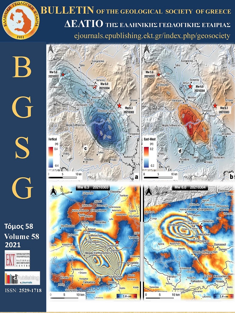
Here we present a joint analysis of the geodetic, seismological and geological data of the March 2021 Northern Thessaly seismic sequence, that were gathered and processed as of April 30, 2021. First, we relocated seismicity data from regional and local networks and inferred the dip-direction (NE) and dip-angle (38°) of the March 3, 2021 rupture plane. Furthermore, we used ascending and descending SAR images acquired by the Sentinel-1 satellites to map the co-seismic displacement field. Our results indicate that the March 3, 2021 Mw=6.3 rupture occurred on a NE-dipping, 39° normal fault located between the villages Zarko (Trikala) and Damasi (Larissa). The event of March 4, 2021 occurred northwest of Damasi, along a fault oriented WNW-ESE and produced less deformation than the event of the previous day. The third event occurred on March 12, 2021 along a south-dipping normal fault. We computed 22 focal mechanisms of aftershocks with M≥4.0 using P-wave first motion polarities. Nearly all focal mechanisms exhibit normal kinematics or have a dominant normal dip-slip component. The use of InSAR was crucial to differentiate the ground deformation between the ruptures. The majority of deformation occurs in the vertical component, with a maximum of 0.39 m of subsidence over the Mw=6.3 rupture plane, south and west of Damasi. A total amount of 0.3 m horizontal displacement (E-W) was measured. We also used GNSS data (at 30-s sampling interval) from twelve permanent stations near the epicentres to obtain 3D seismic offsets of station positions. Only the first event produces significant displacement at the GNSS stations (as predicted by the fault models, themselves very well constrained by InSAR). We calculated several post-seismic interferograms, yet we have observed that there is almost no post-seismic deformation, except in the footwall area (Zarkos mountain). This post-seismic deformation is below the 7 mm level (quarter of a fringe) in the near field and below the 1 mm level at the GNSS sites. The cascading activation of the three events in a SE to NW direction points to a pattern of domino-style earthquakes, along neighbouring fault segments. The kinematics of the ruptures point to a counter-clockwise change in the extension direction of the upper crust (from NE-SW near Damasi to N-S towards northwest, near Verdikoussa).

Article Details
  • Section
  • Natural Hazards
Downloads
Download data is not yet available.
Author Biography
Athanassios Ganas, Editor-in-Chief 2016-2020 Research Director Institute of Geodynamics National Observatory of Athens
Editor-in-Chief BGSG 2016-2018
References
Argyrakis, P., Ganas, A., Valkaniotis, S., Tsioumas, V., Sagias, N., Psiloglou, B., 2020. Anthropogenically induced subsidence in Thessaly, central Greece: new evidence from GNSS data. Nat. Hazards, 102, 179–200. https://doi.org/10.1007/s11069-020-03917-w
Bertiger, W., Desai, S.D., Haines, B., Harvey, N., Moore, A.W., Owen, S., Weiss, J.P., 2010. Single receiver phase ambiguity resolution with GPS data. J Geod, 84, 327–337 https://doi.org/10.1007/s00190-010-0371-9
Briole, P., De Natale, G., Gaulon, R., Pingue, F., Scarpa, R., 1986. Inversion of geodetic data and seismicity associated with the Friuli earthquake sequence (1976-1977), Annales Geophysicae, 4(B4), 481-492.
Briole, P., 2017. Modelling of earthquake slip by inversion of GNSS and InSAR data assuming homogeneous elastic medium, Zenodo. http://doi.org/10.5281/zenodo.1098399
Briole, P., Ganas, A., Elias, P., Dimitrov, D., 2021. The GPS velocity field of the Aegean. New observations, contribution of the earthquakes, crustal blocks model. Geophys. J. Int. 226, 468–492. https://doi.org/10.1093/gji/ggab089
Caputo, R. 1990. Geological and structural study of the recent and active brittle deformation of the Neogene-Quaternary basins of Thessaly (Central Greece). Scientific Annals, 2, Aristotle University of Thessaloniki, Thessaloniki (1990), p. 255, 5 encl.
Caputo, R. 1993. Morphotectonics and kinematics along the Tirnavos fault, northern Larissa plain, mainland Greece, Zeits. für Geomorph. N.F., Suppl.-Bd., 94, pp. 167-185
Caputo, R., 1995. Inference of a seismic gap from geological data: Thessaly (Central Greece) as a case study. Ann. Geofisc., 38 (1), pp. 1-19, 10.4401/ag-4127
Caputo, R., 1996. The active Nea Anchialos Fault System (Central Greece): comparison of geological, morphotectonic, archaeological and seismological data. Annali di Geofisica, 39, 3, 557-574.
Caputo, R., and Pavlides, S., 1993. Late Cenozoic geodynamic evolution of Thessaly and surroundings (Central-Northern Greece). Tectonophysics, 223, 3-4, 339-362.
Caputo, R., B. Helly, S. Pavlides, G. Papadopoulos, 2004. Palaeoseismological investigation of the Tyrnavos Fault (Thessaly, Central Greece). Tectonophysics, 394 (1), pp. 1-20, 10.1016/j.tecto.2004.07.047.
Caputo, R., and Helly, B. 2005. Archaeological evidences of past earthquakes: a contribution to the SHA of Thessaly, Central Greece. J. Earthq. Eng., 9 (2), 199-222, 10.1080/13632460509350539
Caputo, R., Pavlides, S. 2013. The Greek Database of Seismogenic Sources (GreDaSS), version 2.0.0: A compilation of potential seismogenic sources (Mw>5.5) in the Aegean Region, 10.15160/unife/gredass/0200
Caputo, R., B. Helly, D. Rapti, S. Valkaniotis, 2021. Late Quaternary hydrographic evolution in Thessaly (Central Greece): The crucial role of the Piniada Valley. Quaternary International, https://doi.org/10.1016/j.quaint.2021.02.013.
Crotwell, H.P., Owens, T.J., Ritsema, J., 1999. The TauP Toolkit: Flexible Seismic Travel-time and Ray-path Utilities. Seismol. Res. Lett. 70, 154–160. https://doi.org/10.1785/gssrl.70.2.154
Dalla Via, G., Crosetto, M., Crippa, B. 2012. Resolving vertical and east-west horizontal motion from differential interferometric synthetic aperture radar: The L’Aquila earthquake. J. Geophys. Res., 117, B02310. https://doi.org/10.1029/2011JB008689
D'Agostino, N., M. Métois, R. Koci, L. Duni, N. Kuka, A. Ganas, I. Georgiev, F. Jouanne, N. Kaludjerovic, R. Kandić, 2020. Active crustal deformation and rotations in the southwestern Balkans from continuous GPS measurements. Earth and Planetary Science Letters, 539, 116246, https://doi.org/10.1016/j.epsl.2020.116246
Delvaux, D. and Sperner, B. 2003. Stress tensor inversion from fault kinematic indicators and focal mechanism data: the TENSOR program. In: New Insights into Structural Interpretation and Modelling (D. Nieuwland Ed.). Geological Society, London, Special Publications, 212, 75-100.
Drakatos, G., Papanastassiou, D., Voulgaris, N., Stavrakakis, G., 1998. Observations on the 3-D crustal velocity structure in the Kozani-Grevena (NW Greece) area. J. Geodyn. 26, 341–351. https://doi.org/10.1016/S0264-3707(97)00061-6
Ganas, A., Salvi, S., Atzori, S., Tolomei, C., 2006a. Ground deformation in Thessaly, Central Greece, retrieved from Differential Interferometric analysis of ERS-SAR data. 11th International Symposium on Natural and Human Induced Hazards & 2nd Workshop on Earthquake Prediction Abstract Volume, June 22-25, 2006, Patras, Greece, page 41.
Ganas, A, Sokos, E, Agalos, A, Leontakianakos, G, Pavlides S, 2006b. Coulomb stress triggering of earthquakes along the Atalanti Fault, central Greece: Two April 1894 M6+ events and stress change patterns. Tectonophysics, 420, 357–369.
Ganas, A., G. Drakatos, S. Rontogianni, C. Tsimi, P. Petrou, M. Papanikolaou, P. Argyrakis, K. Boukouras, N. Melis and G. Stavrakakis, 2008. NOANET: the new permanent GPS network for Geodynamics in Greece. Geophysical Research Abstracts, Vol. 10, EGU2008-A-04380.
Ganas, A., 2020. NOAFAULTS KMZ layer Version 3.0 (2020 update) (Version V3.0) [Data set]. Zenodo. http://doi.org/10.5281/zenodo.4304613
Ganas, A., Valkaniotis S., Tsironi V., Karasante I., Elias P., Kapetanidis V., Kassaras I., Papathanassiou G. and Briole, P. 2021a. The March 2021 seismic sequence in Larisa - Damasi, Thessaly (central Greece), its seismotectonic characteristics and geodynamic effects. Zenodo. http://doi.org/10.5281/zenodo.4617264
Ganas, A., Elias, P., Briole, P., Valkaniotis, S., Escartin, J., Tsironi, V., Karasante, I., Kosma, C., 2021b. Co-seismic and post-seismic deformation, field observations and fault model of the 30 October 2020 Mw = 7.0 Samos earthquake, Aegean Sea. Acta Geophys. https://doi.org/10.1007/s11600-021-00599-1
Goldstein, R. M.; Werner, C. L. 1998. Radar interferogram filtering for geophysical applications. Geophys. Res. Lett. 25(21), 4035-4038.
Grigoriadis, V.N., Tziavos, I.N., Tsokas, G.N., Stampolidis, A., 2016. Gravity data inversion for Moho depth modeling in the Hellenic area. Pure Appl. Geophys. 173, 1223–1241. https://doi.org/10.1007/s00024-015-1174-y
Hatzfeld, D., Karakostas, Vassilios, Ziazia, M., Selvaggi, G., Leborgne, S., Berge, C., Guiguet, R., Paul, Anne, Voidomatis, P., Diagourtas, Dimitris, Kassaras, Ioannis, Koutsikos, I., Makropoulos, Kostas, Azzara, Riccardo, Bona, M., Baccheschi, S., Bernard, Pascal, Papaioannou, Christos, 1997. The Kozani- Grevena (Greece) Earthquake of 13 May 1995. Revisited from a Detailed Seismological Study. Bulletin of the Seismological Society of America, 87, 473-473.
Hatzfeld, D., Ziazia, M., Kementzetzidou, D., Hatzidimitriou, P., Panagiotopoulos, D., Makropoulos, K., 1999. Microseismicity and focal mechanisms at the western termination of the North Anatolian Fault and their implications for continental tectonics, Geophysical Journal International, Volume 137, Issue 3, pp. 891-908.
Jackson, J. A., Gagnepain, J., Houseman, G., King, G. C. P., Papadimitriou, P., Soufleris, C., & Virieux, J. 1982. Seismicity, normal faulting, and the geomorphological development of the Gulf of Corinth (Greece) the Corinth earthquakes of February and March 1981. Earth and Planetary Science Letters, 57(2), 377– 397. https://doi.org/10.1016/0012-821X(82)90158-3
Kapetanidis, V., 2017. Spatiotemporal patterns of microseismicity for the identification of active fault structures using seismic waveform cross-correlation and double-difference relocation, PhD Thesis, National and Kapodistrian University of Athens.
Kapetanidis, V., Kassaras, I., 2019. Contemporary crustal stress of the Greek region deduced from earthquake focal mechanisms. J. Geodyn. 123, 55–82. https://doi.org/10.1016/j.jog.2018.11.004
Karakostas, C., Klimis, N., Lekidis, V., Makra, K., Margaris, B., Morfidis, K., Papaioannou, C., Rovithis, E., Salonikios, T., Sotiriadis, D., Theodoulidis, N., 2021. ΟΙ ΣΕΙΣΜΟΙ ΤΗΣ ΘΕΣΣΑΛΙΑΣ - Μ6.3, 3 Μαρτίου 2021 και Μ6.1, 4 Μαρτίου 2021. Προκαταρκτική έκθεση. https://doi.org/10.5281/ZENODO.4641200
Karastathis, V., Papoulia, J., Di Fiore, B., Makris, J., Tsampas, A., Stampolidis, A., Papadopoulos, G., 2011. Deep structure investigations of the geothermal field of the North Euboean Gulf, Greece, using 3-D local earthquake tomography and Curie Point Depth analysis. Journal of Volcanology and Geothermal Research, 206. https://doi.org/10.1016/j.jvolgeores.2011.06.008
Kilias A., Mountrakis D., 1989. The Pelagonian nappe. Tectonics, metamorphism and magmatism. (In Greek with English abstract). Bull. Geol. Soc. Greece, 23(1), 29-46.
King, G. C. P., Stein, R. S., and Rundle, J. B. 1988. The Growth of Geological Structures by Repeated Earthquakes 1. Conceptual Framework, J. Geophys. Res., 93 (B11), 13307– 13318, doi:10.1029/JB093iB11p13307.
King, G.C.P., Stein, R.S., Lin, J., 1994. Static stress changes and the triggering of earthquakes, Bull. Seism. Soc. Am., 84(3), 935-953.
Kiratzi, A.A., Wagner, G.S., Langston, C.A. 1991. Source parameters of some large earthquakes in Northern Aegean determined by body waveform inversion. Pure Appl. Geophys. PAGEOPH 135, 515–527, https://doi.org/10.1007/BF01772403
Konstantinou, Κ.Ι, 2017. Accurate relocation of seismicity along the North Aegean Trough and its relation to active tectonics. Tectonophysics, 717, 372-382.
Konstantinou, K. I., V. Mouslopoulou, W.-T. Liang, O. Heidbach, O. Oncken, and J. Suppe 2016. Present-day crustal stress field in Greece inferred from regional-scale damped inversion of earthquake focal mechanisms. J. Geophys. Res. Solid Earth, 121, doi:10.1002/2016JB013272.
Lekkas, E.L., Mavroulis, S.D. 2016. Fault zones ruptured during the early 2014 Cephalonia Island (Ionian Sea, Western Greece) earthquakes (January 26 and February 3, Mw 6.0) based on the associated co-seismic surface ruptures. J Seismol 20, 63–78. https://doi.org/10.1007/s10950-015-9510-3
Lekkas, E., K. Agorastos, S. Mavroulis, Ch. Kranis, Emm. Skourtsos, P. Carydis, M. Gogou, K.-N. Katsetsiadou, G. Papadopoulos, I. Triantafyllou, A. Agalos, S. Moraitis, E. Stamati, D. Psarris, G. Kaviris, V. Kapetanidis, P. Papadimitriou, A. Karakonstantis, I. Spingos, V. Kouskouna, I. Kassaras, K. Pavlou, N. Voulgaris, M. Mavrouli, S. Pavlides, A. Chatzipetros, S. Sboras, E. Kremastas, A. Chatziioannou, A. Kiratzi, C. Papazachos, N. Chatzis, V. Karakostas, E. Papadimitriou, Ι. Koukouvelas, Κ. Nikolakopoulos, Α. Kyriou, D. Apostolopoulos, V. Zygouri, S. Verroios, A. Belesis, I. Tsentzos, P. Krassakis, K. Lymperopoulos, A. Karavias, D. Bafi, T. Gatsios, M. Karatzia, I. Gkougkoustamos, T. Falaras, I. Parcharidis, G. Papathanassiou, C.P. Evangelidis, V. Karastathis, G-A. Tselentis, A. Ganas, V. Tsironi, I. Karasante, S. Valkaniotis, D. Galanakis, G. Kostantopoulou, N. Theodoulidis, Ch. Karakostas, V. Lekidis, K. Makra, V. Margaris, K. Morfidis, Ch. Papaioannou, M. Rovithis, Th. Salonikios, N. Papadopoulos, A. Kourou, M. Manousaki, T. Thoma 2021. The early March 2021 Thessaly earthquake sequence. Newsletter of Environmental, Disaster and Crises Management Strategies, 22, ISSN 2653-9454.
Lomax, A., 2014. Seisgram2K, Seismogram visualization and analysis software version 7.0, http://alomax.free.fr/seisgram/SeisGram2K.html
Mantovani, A., Valkaniotis, S., Rapti, D. et al. 2018. Mapping the Palaeo-Piniada Valley, Central Greece, Based on Systematic Microtremor Analyses. Pure Appl. Geophys. 175, 865–881. https://doi.org/10.1007/s00024-017-1731-7
Migiros, G. 1985. Geological map of Greece in 1:50,000 scale, map sheet Gonnoi. Institute of Geological & Mineralogical Exploration, Athens.
Mountrakis, D., 1984. Structural evolution of the Pelagonian Zone in Northwestern Macedonia, Greece. Geological Society, London, Special Publications, 17, 581-590, https://doi.org/10.1144/GSL.SP.1984.017.01.45
Mountrakis, D., Kilias, A., Pavlides, S., Zouros, N., Spyropoulos, N, Tranos, M., and Soulakelis, N. 1993. Field study of the southern Thessaly highly active fault zone, in Proc. 2nd Congress Hellenic Geophys. Union, 2, 603-614.
Müller, M.D., A. Geiger, H.G. Kahle, G. Veis, H. Billiris, D. Paradissis, S. Felekis, 2013. Velocity and deformation fields in the North Aegean domain, Greece, and implications for fault kinematics, derived from GPS data 1993–2009. Tectonophysics, 597, pp. 34-49.
Novotný, O., Zahradník, J., Tselentis, G.-A. 2001. Northwestern Turkey Earthquakes and the Crustal Structure Inferred from Surface Waves Observed in Western Greece. Bulletin of the Seismological Society of America, 91(4), 875–879. https://doi.org/10.1785/0120000116
Okada Y., 1992. Internal deformation due to shear and tensile faults in a half space, Bull. Seism. Soc. America, 82, 1018–1040.
Palyvos, N., Pavlopoulos, K., Froussou, E., Kranis, H., Pustovoytov, K., Forman, S.L., Minos-Minopoulos, D., 2010. Paleoseismological investigation of the oblique-normal Ekkara ground rupture zone accompanying the M 6.7–7.0 earthquake on 30 April 1954 in Thessaly, Greece: Archaeological and geochronological constraints on ground rupture recurrence. J. Geophys. Res. 115, B06301. https://doi.org/10.1029/2009JB006374
Papadimitriou, E.E, Karakostas, VG., 2003. Episodic occurrence of strong (Mw≥6.2) earthquakes in Thessalia area (central Greece), Earth and Planetary Science Letters, Volume 215, Issues 3–4, 395-409, https://doi.org/10.1016/S0012-821X(03)00456-4.
Papastamatiou, D., Mouyaris, N., 1986. The earthquake of April 30, 1954, in Sophades (Central Greece). Geophys. J. R. astr. Soc., 87, 885-895.
Papazachos, B.C., Panagiotopoulos, D.G., Tsapanos, T.M., Mountrakis, D.M., Dimopoulos, G.C., 1983. A study of the 1980 summer seismic sequence in the Magnesia region of Central Greece. Geophys. Jour. R. astron. Soc. London, 75, 155-168.
Papazachos, B.C., P.M. Hatzidimitriou, G.F. Karakaisis, C.B. Papazachos, G.N. Tsokas, 1993. Rupture zones and active crustal deformation in southern Thessalia, central Greece, Boll. Geof. Teor. Appl. 139, 363-374.
Pavlides S., 1993. Active faulting in multi-fractured seismogenic areas; examples from Greece. Z. Geomorph. N. E., 94, 57-72.
Pavlides, S., Kouskouna, V., Ganas, A., Caputo, R., Karastathis, V., Sokos, E., 2004. The Gonnoi (NE Thessaly - Greece) Earthquake (June 2003, Ms=5.5) and the Neotectonic Regime of Lower Olympus. 5th International Symposium on Eastern Mediterranean Geology, Thessaloniki, Greece, 14-20 April 2004, 627-630.
Plastiras, V. 1985. Geological map of Greece in 1:50,000 scale, map sheet Larissa. Institute of Geological & Mineralogical Exploration, Athens.
Rigo, A., Chabalier, J.-B. de, Meyer, B., Armijo, R., 2004. The 1995 Kozani-Grevena (northern Greece) earthquake revisited: an improved faulting model from synthetic aperture radar interferometry. Geophys. J. Int. 157, 727–736. https://doi.org/10.1111/j.1365-246X.2004.02220.x
Salvi, S., Ganas, A., Stramondo, S., Atzori, S., Tolomei, C., Pepe, A., Manzo, M., Casu, F., Berardino, P., Lanari, R., 2004. Monitoring Long-Term Ground Deformation by SAR Interferometry: Examples from the Abruzzi, Central Italy, and Thessaly, Greece. 5th International Symposium on Eastern Mediterranean Geology, Thessaloniki, Greece, 14-20 April 2004, Reference T7-17.
Soufleris, C., J.A Jackson, G.C.P King, C Spencer, C Scholz, 1982. The 1978 earthquake sequence near Thessaloniki (northern Greece). Geophysical Journal of the Royal Astronomical Society, 68 (1982), pp. 429-458.
Stamatis, A. 1987. Geological map of Greece in 1:50,000 scale, map sheet Deskati. Institute of Geological & Mineralogical Exploration, Athens.
Taymaz, T., Jackson, J.A., McKenzie, D., 1991. Active tectonics of the north and central Aegean Sea, Geophys. J. Int., 106, 433-490.
Taymaz, T., Ganas, A., Yolsal-Çevikbilen, S., Vera, F., Eken, T., Erman, C., Keleş, D., Kapetanidis, V., Valkaniotis, S., Karasante, I., Tsironi, V., Gaebler, P., Melgar, D., Ocalan, T., 2021. Source Mechanism and Rupture Process of the 24 January 2020 Mw 6.7 Doğanyol-Sivrice Earthquake obtained from Seismological Waveform Analysis and Space Geodetic Observations on the East Anatolian Fault Zone (Turkey), Tectonophysics, https://doi.org/10.1016/j.tecto.2021.228745
Toda, S., Stein, R.S., Sevilgen, V., Lin, J., 2011. Coulomb 3.3 Graphic-rich deformation and stress-change software for earthquake, tectonic, and volcano research and teaching-user guide. U.S. Geological Survey Open-File Report 2011-1060, 63, http://pubs.usgs.gov/of/2011/1060/
Tolomei C., Caputo R., Polcari M., Famiglietti NA., Maggini M., Stramondo S., 2021. The Use of Interferometric Synthetic Aperture Radar for Isolating the Contribution of Major Shocks: The Case of the March 2021 Thessaly, Greece, Seismic Sequence. Geosciences. 11(5):191. https://doi.org/10.3390/geosciences11050191
Tranos, M., E. Papadimitriou, A. Kilias, 2003. Thessaloniki-Gerakarou Fault Zone (TGFZ): the western extension of the 1978 Thessaloniki earthquake fault (northern Greece) and seismic hazard assessment. J. Struct. Geol., 25, pp. 2109-2123
Triantafillis, E. 1987. Geological map of Greece in 1:50,000 scale, map sheet Elassona. Institute of Geological & Mineralogical Exploration, Athens.
Tsodoulos, I.M., K. Stamoulis, R. Caputo, I. Koukouvelas, A. Chatzipetros, S. Pavlides, C. Gallousi, C. Papachristodoulou, K. Ioannides, 2016. Middle-Late Holocene earthquake history of the Gyrtoni Fault, Central Greece: insight from optically stimulated luminescence (OSL) dating and paleoseismology, Tectonophysics, 687, 14-27, 10.1016/j.tecto.2016.08.015
Valkaniotis S., Ganas A., Papathanassiou, G., and Papanikolaou M., 2014. Field observations of geological effects triggered by the January-February 2014 Cephalonia (Ionian Sea, Greece) earthquakes, Tectonophysics, 630, 150-157, DOI:10.1016/j.tecto.2014.05.012
Valkaniotis, S., Papathanassiou, G., Ganas, A., Kremastas, E., Caputo, R., 2021. Preliminary report of liquefaction phenomena triggered by the March 2021 earthquakes in Central Thessaly, Greece. https://doi.org/10.5281/ZENODO.4608365 released (2021, March 16).
Veci, L., Lu, J., Prats-Iraola, P., Scheiber, R., Collard, F., Fomferra, N., Engdahl, M., 2014. The Sentinel-1 toolbox. In: Proceedings of the IEEE International Geoscience and Remote Sensing Symposium (IGARSS). IEEE, pp. 1–3.
Vidakis, M. 1998. Geological map of Greece in 1:50,000 scale, map sheet Farkadona. Institute of Geological & Mineralogical Exploration, Athens.
Waldhauser, F., 2001. hypoDD—A Program to Compute Double-Difference Hypocenter Locations: U.S. Geological Survey Open-File Report 01-113, 25 pp., https://pubs.usgs.gov/of/2001/0113/ .
Waldhauser, F., Ellsworth, W. L. 2000. A Double-difference Earthquake location algorithm: Method and application to the Northern Hayward Fault, California. Bulletin of the Seismological Society of America, 90(6), 1353–1368. https://doi.org/10.1785/0120000006
Wessel, P., Luis, J. F., Uieda, L., Scharroo, R., Wobbe, F., Smith, W. H. F., Tian, D. 2019. The Generic Mapping Tools version 6. Geochemistry, Geophysics, Geosystems, 20, 5556–5564.
Wright, T.J., Parsons, B., Lu, Z. 2004. Toward mapping surface deformation in three dimensions using InSAR. Geophysical Research Letters, 31 (1), L01607. https://doi.org/10.1029/2003GL018827
Most read articles by the same author(s)